


Photos and Essay by Eric F. Coppolino
Interview above is with Luella Kenney, a former Love Canal resident and co-organizer of the evacuation. Full Friday night edition of Planet Waves FM is here. Please tap the headline for larger images. This is a project of Chiron Return - Planet Waves FM.
A map of the original Love Canal community is included at the bottom of the page, followed by a contemporary satellite photo with streets indicated. This report will be part of the Love Canal collection at the State University of New York at Buffalo archives.
NIAGARA FALLS, NY, Sept. 4, 2023 — The photo above, of a suburban street corner on a beautiful summer afternoon, sums up the story of the Love Canal neighborhood. At its essence, it’s about what happened after an elementary school was built on a toxic waste dump, then surrounded by homes and apartments for nearly 1,000 families.
It seems like such a lovely place.
The strange name of the community comes from an early owner of the land, a local entrepreneur named William T. Love. He once dug a canal that he planned to use for generating hydroelectric power, diverting water from the nearby Niagara River.
When that project never happened, the canal was used as a toxic waste dump by the Hooker Chemical Co. The 99th St. Elementary School was built right over the landfill, and the rest of the property was sold to home developers. Then tragedy ensued.
I first covered the crisis in September 1983, as a student editor at the University of Buffalo, half an hour away. After the initial evacuation and demolition of the worst-affected homes, the state planned to resell the remaining houses to unsuspecting buyers. My article was called Resettling Love Canal Amidst Unsettling Questions.
The Fence and the Rise in Grade
The picture above is deceptively serene. To sort out what is happening, you need to ask what that fence is doing there, and why the grade rises by about eight feet on the other side.
The little hill is a clay “cap” on top of the chemical and nuclear dump, which was filled with about 20,000 tons of industrial waste between approximately 1942 and 1952. This included a brew of about 250 different chemicals, including high concentrations of dioxins. The pile of clay is intended to keep rainwater from percolating through the ground, and to prevent the barrels from popping up.
As environmental historian Peter Montague wrote, Love Canal “is the place where the modern toxics movement began.”
The street in the photo above, 98th St. in Niagara Falls, NY, used to continue south for another two blocks, once ending at the edge of a schoolyard located directly over the dump site. The whole neighborhood extended about six blocks to the south as well, to Frontier Ave. at the south end (there is a map below).
Eric F. Coppolino is the host of Planet Waves FM on Pacifica Radio. He is executive director of Chiron Return, a nonprofit investigative team which provides mentorship opportunities for journalists. efc@planetwaves.net or (845) 337-5095.
The Niagara Falls Board of Education purchased what it knew was a chemical dump, built two elementary schools, and then sold the rest of the land to developers. One thousand homes were built around it.
Today, most of the neighborhood is no longer there, but some of it is.
The issues have been well-known in the community for 47 years. In 1976, the public became aware, through a series of local newspaper articles, that the Niagara Falls Board of Education had purchased the land from Hooker Chemical Co., knowing it was a chemical waste dump.
The public record includes a description of Hooker executives taking school board members to the location and poking a stick into the ground, demonstrating that it came up coated with toxic waste. Hooker executives argued that the land was not suitable for a school. The school board threatened to take the land by eminent domain, so instead, Hooker sold them the land for $1 and included a warning about the chemicals in the deed.
An elementary school was constructed and a neighborhood was built around it, and the remaining land was sold to housing developers. Then another school was built a few blocks away. The community of about 1,000 homes included an affordable housing apartment complex with 304 apartment units.
By the mid-1970s, many children and some adults throughout the neighborhood were getting sick. In 1976, reporters for the Niagara Gazette had informed the community of the land’s history, but the reports were not taken seriously. This was a company town — many of the men who lived in the neighborhood worked in the chemical plants nearby. Residents loyal to the chemical companies claimed the articles were sensationalized and overblown. They turned out to be not just correct, but understated.

Then came the blizzard of 1977
Melt-off water from the infamous blizzard of 1977 flooded the dump and pushed chemicals — including barrels — to the surface. The underground “canal” was also flooded, displacing chemicals and pushing them out laterally into the community.
Under the leadership of a then-housewife, Lois Gibbs, Love Canal residents finally organized and demanded an evacuation and the purchase of their homes. The Love Canal was declared the first Superfund site. However, parts of the community — such as north of the dump site, seen in Photo 1 below, were not condemned.
Some of those homes were purchased by a state agency called the Love Canal Area Revitalization Agency, and resold to newcomers. Land where some homes previously stood was developed into a senior citizen housing complex that opened in 1999 — two decades after the community was initially evacuated and made into the first Superfund site.
The photo tour below shows the Love Canal dioxin dump and the surrounding neighborhood as they appeared Labor Day weekend of 2023.

Link to Friday’s full Planet Waves FM edition.
Additional Resources:
Love Canal Digital Archive at SUNY Buffalo
Lois Gibbs Love Canal Papers at Tufts University
Resettling Love Canal Amidst Unsettling Questions by Eric F. Coppolino, published in the SUNY Buffalo student magazine, Sept. 27, 1983.
NYS Department of Health report and order from 1988 declaring land east of the Love Canal uninhabitable, suitable only for industrial use. I would estimate that about 10 homes are still occupied in the eastern part of the neighborhood.
Recent New York Times coverage of unsuspecting people moving to Love Canal
Retrospective 2013 report from The New York Times
The Secret History of Chemicals, featuring Carol van Strum on Planet Waves FM
Paradise Falls by Keith O’Brien, a recent book that includes biographies of Lois Gibbs and Luella Kenney (whom I have interviewed above).
East Palestine: It’s the Dioxin by Eric F. Coppolino
Dioxin Dorms — Documenting the 1991 contamination of Bliss, Capen, Gage and Scudder halls at SUNY New Paltz by Eric F. Coppolino
Conspiracy of Silence by Eric F. Coppolino, 1994, Sierra coverage of the toxic legacy of Monsanto, GE and Westinghouse.

1.
ALL OF THE LOVE CANAL NEIGHBORHOOD in Niagara Falls, New York, used to look like the photo above. It consisted of about 1,000 homes that were built in the 1950s and 1960s — unbeknownst to homeowners, on top of and surrounding an industrial waste dump. The section of the neighborhood above, north of the dump site, is still inhabited, despite the fact every yard will test positive for dioxins.
Measured in picograms and parts-per-trillion, there is no safe level of exposure. Every dose adds to what is already there. Dioxins are especially dangerous to children, whether born or unborn.
Contamination from a brew of more than 250 chemicals dumped, by the barrel, into an abandoned canal, and still leaches into the remaining homes through the basements. It collects from groundwater in sumps (basement drainage systems) and contaminates the pumps that dispose of that water in the local storm sewer system. And then it spreads to the air inside those homes, seeping up from basements and rising up through drains connected to the city sewers.
There are monitor wells throughout the neighborhood (both the demolished parts and those still used) where samples are taken to determine the flow of toxins under the ground. Additionally, contaminated storm sewers flow into streams which converge to the northeast (behind the photo to the left), in the midst of people’s homes.
While the neighborhood shown above still exists, many nearby streets and 833 homes have been erased — abandoned, condemned, sold to the state and demolished — and replaced by a strange field surrounded by a green fence. Other abandoned or condemned areas are treated by locals as a wildlife preserve — a quiet place to walk their dogs and to be in what seems like nature.

2.
The photo above was the approximate location of the LaSalle affordable housing complex — many small apartment buildings with 304 residences that have been demolished due to contamination. Today, wildflowers grow, and there are decaying driveways that lead nowhere.
Deer, rabbits, raccoons, foxes, and many kinds of birds seem to thrive in the area, along with abundant wildflowers and trees. After much work, the problem seems to be contained below the ground. Yet chemicals seep through the earth and move in all directions through the groundwater.
The area is located close to the Niagara River, about five miles upstream from the famous waterfall. So the water table is high. Toxins seep into homes by way groundwater into basement sumps, thereby directing toxic water into the sewers, rotting out sump pumps and depositing black, a tar-like substance in them.

3.
The first person I met on my visit to love canal was the Rhodesian Ridgeback, Scoobie. Still a puppy, Scoobie has had his tail removed due to a massive tumor. He is friends with the woman above, who lives in a home on 93rd St. with her husband and four young children. This is immediately to the west of the Love Canal and across from the now-demolished LaSalle affordable housing complex.
There is a high probability you could sweep up grime from the street, or take a sample of the lawn soil, and find high levels of dioxin. There is no safe level of exposure. Any amount poses a danger.
She says it’s a much safer neighborhood than downtown where she grew up; she’s not afraid of getting shot. There is little traffic, so it’s safe for her kids to play and cross the street. Their mortgage on a three-bedroom home is only $1,000. But she also said she felt pressured into taking the home by her realtor.
She told me that the child of a previous owner of her home died of what she called “childhood cancer.” She takes beautiful wildlife photos in the woods surrounding the Love Canal dump. To her, it’s a nature sanctuary. All the homes across the street from where she lives — including an affordable housing apartment complex — have been demolished. A few new ones have been built, on the north end of 93rd St.
However, after our conversations and tour of the city, she said she is planning to get out somehow. The question is, can she sell her home to another family in good conscience?

4.
The main clue that there’s a problem is this green fence, shown here as it runs south along 95th St. It’s everywhere you look, encompassing an area about five blocks wide, all the way east to 100th St., far to the left of this view.
It spans from Colvin Blvd. on the north boundary to Frontier Ave. on the south (see map at the bottom of the page). Then it surrounds a 40-acre field on all sides. The fence is discreet and friendly-looking enough. It’s just off to the side nearly everywhere you go; the thing seemed to follow me around everywhere, like the Moon.
There are no signs that say that it’s a chemical and nuclear waste dump; rather, the signs merely say “Private Property.” They do a fine job of hiding the massive dump site from residents who do not know the extent of what happened, mainly with dishonest signs and by keeping the grass mowed.

5.
If you look closely at the photo above, you can see strange things, like the homes to the left with their backyard separated from the chemical dump by the fence. This is where 96th St. ends with areas east of it having been demolished.
The family that occupies this particular home was having a Labor Day barbecue while I roamed around the streets surrounding their yard taking photos.
The lake of toxic chemicals have been leaching under the ground since they were put there in the 1940s and 1950s. You could never, ever get me to go in their basement, and I cannot understand how they don’t notice the sludge or the stench.

6.
Behind and to the left of the home shown in the prior image is a new playground for children, sponsored by the Niagara Falls Youth Bureau. Due to their low body weight, small people are the most impacted by the levels of dioxin in any environment (or in food).
If you look you can see the fence separating it from the Love Canal, and also see the raised-grade clay cap, which is illuminated in the center-left of the image. This scene faces 95th/96th streets.
This modern playground — built recently — is used frequently by moms with small children. It’s part of an old community center that was built along with the neighborhood early in its history. The community center is still used regularly for senior citizen luncheons.

7.
Other places, it’s more obvious that something is wrong. In the image above, the view is from a driveway onto 95th St. This location now faces the fence and a chemical waste processing facility that has been built on the site of the chemical dump. That is the yellow and brown building toward the upper left of the picture. It’s a reminder that this whole community is floating on a bubble of chemical and nuclear waste that is slowly leaching out in all directions. The chemicals “processed” by this facility are said to be nontoxic and are dumped into the Niagara River. They flow down the falls, and some are inhaled by tourists riding the Maid of the Mist at the bottom of the falls.

8.
The photo above looks at the same location from the other direction than from above, from 95th St. inward toward the building lot. This was once an entrance to the LaSalle affordable housing complex, which was situated right next to the chemical dump. I think of this scene as showing archeological ruins of the civilization that once stood here. The complex was taken over by the state and demolished. Slowly, the land is reclaiming the man-made features.

9.
Everywhere, there are little signs of what used to be. The picture above is at what’s now the end of 99th St., facing south, about a block north from where the infamous 99th St. Elementary School was located. This would be an ideal location for a Love Canal memorial.
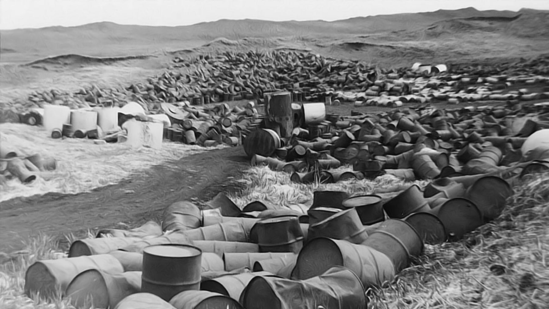
(Here is a photo of the school being demolished around 1980. The street in front of the demolition is 99th St. (same as above), which originally extended further south, all the way through the development, over the dump, and then ended at Frontier Ave. The link reveals a chilling image — the last memory of a school built right on top of the dioxin dump, where many students became sick.
The 93rd St. Elementary School, several blocks northwest of this location (behind, and to the right), was also demolished. Though located further from the Love Canal, it was in an area contaminated by dioxin moving through several creeks that transported the chemicals throughout the neighborhood.
So much for the school district buying the land — which it knew contained a chemical dump — for a buck. One dollar. It may seem that Hooker Chemical, because it warned the school district repeatedly about the problem, is not responsible. But they fought cleanup and evacuation efforts in order to conceal many other dumps in the region.

10.
Things start to get really strange when you go to the east side of the dump. Currently this begins at 100th St. (shown above, the street runs north); 99th St. (shown in the archival image below) and several streets to the west were condemned, demolished and erased from the Earth. — The fence was expanded to encompass the land where they once stood.
A 1988 decision and report by the New York State Department of Health declared the area east of the Love Canal to be uninhabitable, suitable only for industrial use. Today that includes residences on 101st, 102nd and 103rd, of which I estimate that under 10 are currently occupied or recently abandoned. Here is the story of one such resident, who had no idea where he was moving.
The fence (shown above to the left, covered with ivy in this area) now runs north where the curb of 100th St. used to be, looking up the street from Frontier Ave. Utility poles have all been removed. The homes were demolished into their foundations.
This scene resembles a quiet country lane rather than a suburban street. It’s difficult to imagine that it had houses, yards, mailboxes running up both the left and right sides. All of that has been removed, and it’s gradually returning to forest.

11.
For comparison, the scene above is the now-demolished 99th St., looking north from Frontier Ave. — the same basic perspective as the photo above (which is 100th looking north from Frontier). It was taken after the homes were condemned but before they were demolished, probably some time in 1983 or 1984. What was 99th St. is now enclosed inside the Love Canal fence.
When I first visited in the summer of 1983, the homes were still there and no fence was in place, as I wandered freely in the backyards in the middle of the night. Then some time later, I visited again, and the utility poles were sticking up out of the ground after the grade had been raised about eight feet by the clay cap. Then the utility poles were removed.
The area shown above — 99th St, on the east side of the Love Canal— is now considered part of the toxic waste dump, and is inside the green-fenced area. It’s one block east (toward the dump) from the location of the fence, shown below.

12.
Frontier Ave. runs along the south side of the Love Canal. This is the condemned and abandoned sidewalk starting at 100th St., facing west toward the lower-numbered streets. The Love Canal dump is to the right; to the left is an expressway, then another infamous chemical contamination zone (the 102nd St. dump), and then the Niagara River, leading to the world-famous Niagara Falls a few miles downstream.

13.
Here is a perspective shot of the intersection of Frontier Ave. and 100th St., facing northwest. It is the southeast corner of the Love Canal (same approximate location as Photo 12). The expressway, the 102nd St. dump and the Niagara River are to the left. When you see this, imagine it as a teeming, vibrant neighborhood with homes extending the length of both streets and all through the fenced-in area.

14.
This is an abandoned street east of the dump — close to several prior photos — though facing south toward Frontier (the images above are all facing north or northerly). I am standing fairly close to Colvin Blvd., looking down most of the length of the street toward Frontier Ave. I am not sure whether it’s 101st or 102nd (Luella can’t tell either). Both have had nearly all of the homes removed. (I am thinking it’s probably 102nd).
Imagine this scene 50 years ago — as a street lined with homes, yards, mailboxes, driveways with cars, and children playing — a picture of the American Dream. Today, it’s silent and desolate, a monument to the lost lives and life patterns of the mostly-young families who lived there.
It is a tribute to the disregard of the future that is inherent in American society.
Though I know that evening's empire has returned into sand
Vanished from my hand
Left me blindly here to stand, but still not sleeping
My weariness amazes me, I'm branded on my feet
I have no one to meet
And the ancient empty street's too dead for dreaming
— Bob Dylan

15.
The land to the east of the dump site — from 100th St. out to 103rd, where the development ends — is a world of its own. It’s unlike anyplace I’ve ever been.
Several abandoned houses still exist back there, and are slowly crumbing — but not many, perhaps three or four. Then there are maybe five or six remaining inhabited homes in total along 101st, 102nd, and 103rd (which is a very short street, mostly undeveloped). This abandoned home (shown above) is at 602 102nd St. There are two cars in the overgrown yard, indicating that its owner died. The house has a “For Sale” sign but I don’t think it’s going anywhere.
The empty field behind the home is the Love Canal dump. You can always tell by either the fence, or the fact that the grade is raised above the normal ground level. The grass is also a little lighter than the surrounding vegetation.

16.
One block over on 103rd St. are two homes, one abandoned, and one inhabited by renters who say they want to get out. This photo with the wheelchair is the shot from the front yard of the recently foreclosed, abandoned home on the east side of 103rd looking toward the inhabited one.

17.
Some of the remaining homes are impeccably well-kept and look like something out of a fairy tale. This residence is on 101st St., one block from the dump site fence. It is difficult to imagine how anyone can live here — and I would not want to go into the basement.

18.
Yet just up the street is a truck graveyard along 101st St., one of several industrial sites that now exist where residential streets and lovely little homes once stood. The land east of the dump has been approved by the New York State Department of Health for industrial use only. Sale and transfer of the few remaining homes in the former neighborhood seems to be allowed.

19.
This photo is taken from 101st St., looking eastward one block over former home lots to 102nd. It’s in the eerie abandoned suburb that now resembles rural land.
The owner of this particular home, a young man of about 25, looks like he stepped out of a Steinbeck novel: handsome, taciturn, wearing work boots and greasy Carhartt jeans and tee shirt. He said he’s a diesel engine mechanic and heavy equipment operator who can take apart any kind of engine and put it back together.
He’s made many improvements to this typical Love Canal dwelling the past two years. They include a new roof, a pretty blue paint job that gleams in the late afternoon sunlight, and rewiring the entire structure.
He’s the kind of guy who knows everything about everything. He provided me with a 10-minute rant about how toxic the whole world is; it would have made a great YouTube, if he hadn’t been smoking one cigarette after the next. (He would not let me photograph him.)
When I pressed him for his understanding of where he lived, however, he pretended not to grasp the extent of the contamination that has seeped under his home from the dioxin dump located just two blocks to the west. But if he’s rewired the whole building, then presumably he’s familiar with his sump pump and the surrounding drainage facilities in the basement.
He plans to flip the home for $110,000. It last sold for $50,000, in late 2020. The new buyers will no doubt feel they have gotten an excellent deal on a well-maintained home, which backs against a beautiful forest. He, too, will take part in the deception of Love Canal — by concealing the extent of the problem from the new owners. Since he and I spoke, he understands the situation. But he is intent on getting his investment back.

20.
The underlying reality of this community is that a chemical and nuclear waste dump is at its center, seeping out in all directions. This is a closeup of the “clay cap” behind the fence. The vents and monitor wells shown above are seen from the remaining stump of 99th St. at the north end of the Love Canal, facing an occupied neighborhood to the west. In the background is an occupied home, one of those closest remaining dwellings to the dioxin dump. This location is just one block from where the 99th St. Elementary School stood.

21.
To the southwest of the pipes above, diagonally across the fenced-in area and just outside of it, is a relatively new Vincent Morello senior citizen housing facility that opened in 1999 — twenty years after the evacuation more than 800 families from the same neighborhood. This facility is located along 95th St. near Frontier Ave. They have a great view of the Love Canal, but most have no idea what it is. The motto of the facility is, “Where Love Lives.”

22.
It is difficult to imagine how any of this is possible, though in truth, it’s commonplace. Many communities are built on, adjacent to or within the watershed of toxic waste dumps.
This photo, taken from 93rd St., shows barricades on Read Ave., a street once leading to the LaSalle affordable housing complex. In the background are more homes located in proximity to the toxic reservoir.

I spent a day-and-a-half photographing the Love Canal, Sunday afternoon and early evening Sept. 2, 2023, and then all day Sept. 3 (Labor Day). On the morning of the 4th, I woke up to this vision coming through my hotel room window.
I briefly considered going back to the Love Canal for one last look before I left the area, and to catch any photos I might have missed. I thought the better of it. Instead, I packed my cameras and guitar into my car, drove directly out of Niagara Falls, got on the New York Thruway — and had breakfast 90 miles away in Rochester.

the thing I came for:
the wreck and not the story of the wreck
the thing itself and not the myth
the drowned face always staring
toward the sun
the evidence of damage
worn by salt and sway into this threadbare beauty
the ribs of the disaster
curving their assertion
among the tentative haunters.
— Adrienne Rich

Postscript — the rest of the city.
The woman seen above playing with the Rhodesian Ridgeback grew up in the downtown area of the city, in the 1990s. We went on a long car ride, visiting her old neighborhood, and others. They are a war zone. As we drove through the streets, she told me exactly who was killed and where, mostly from gang violence.
She demonstrated that the homes in the Love Canal area are some of the nicest housing stock in the city, and on one level, the safest place to live.
The photo above is a view of downtown, in “the honeymoon capital of the world.” That is looking north on Main St. at the corner of Michigan. The city is a wasteland, and everywhere I went, someone was telling me the location of another chemical or nuclear dump. An old study once concluded that (from the standpoint of chemical exposure) it’s as safe to live in the Love Canal as it is to live anywhere else in Niagara Falls. So I could see why people choose to live there.


Share this post